


It's been frigid up here in WNY this February. It's been the coldest month since record keeping began in this neck of the woods. And it was cold enough to freeze Niagara Falls. It seems like pictures of the frozen Falls have been posted just about everywhere, but I figured that some of you just might appreciate seeing some pics taken by an old cpaptalk.com friend who happens to live near NF.
Hubby and I went up to NF on Saturday, Feb. 28. This was about 3 days after the most severe and extensive "freezing" of the falls had been noticed. But it had stayed cold the whole week and we figured that there would still be a lot of snow and ice and frozen falls to look at. I posted about 30 pictures over on my photobucket account. You should be able to access those pictures by going to http://s1198.photobucket.com/user/robys ... sort=2&o=0 and browsing the whole album.
But here are some shots that I'm particularly proud of:
This picture is wide angle shot showing the entire American Falls area. Goat Island is on the right side; Niagara Falls, NY is on the left side. Luna Island is the frozen caplike structure nearest Goat Island. The frozen caplike structure that is closer to the left side of the picture is frozen Falls. This picture was taken from Victoria Park on the Ontario side.

This next picture was taken from pretty close to the Victoria Park area on the Canadian side. It's a bit more zoomed in on the frozen stuff than the previous picture was. It shows the full beauty of the partially frozen American falls. On the far left you can see freezing in the falls. They appear to actually be frozen on the far left side of the picture. In the middle of the shot there's a spot where the falls have clearly thawed (or didn't fully freeze last week). The next batch of ice that's hanging down is an ice cap on the edge of Luna Island, which seperates the Bridal Falls (to the right of the picture) from the rest of the American falls (to the left of the picture). At the bottom right corner of the picture is the remnants of this year's Cave of the Wind tour. They have to rebuild the wooden walkways each spring, and this picture makes it clear why. The Cave of the Winds's Hurricane Deck will be rebuilt somewhere on that frozen stretch between the visible wooden structure and that mass of snow and ice between it and the Bridal Falls.

This one shows the snow and ice around Luna Island, which separates the small Bridal Veil Falls (to the right) from the rest of the American Falls (to the left).

This picture is just to the left of the previous one: Luna Island is just outside the right edge of the picture frame in this shot. So all the ice and freezing at the top of the falls is really Frozen Niagara Falls ice. This picture also shows the massive ice jams and ice floes that have developed in front of the American Falls.

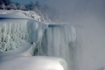
The next shot shows the Goat Island cliff that separates the American Falls from the Horseshoe Falls. The ice cycles really had a decided aqua-green tinge to them, so the color balance in this picture is pretty accurate:

There were lots of rainbows the day we were up there. Here's one that extends all the way down to the base of the Horseshoe Falls. Notice the ice floe on the left side of the picture: That's about where the Maid of the Mist gets up to in the summer time:

And finally, here's a zoomed shot of the American end of the Horseshoe Falls. The picture was taken from the Table Rock area on the Canadian side. You can see that there is still some freezing in the fall itself in the middle-right side of the picture, along with a lot of ice right at the edge of the waterfall on the left side of the frame. I'm currently using a cropped version of this shot for my FB profile shot. I may change my profile picture over here to this shot for at least a little while.


